[颱風] 01C 艾歐娜 中太連續兩年破蛋


風場+結構達標 緊急命名
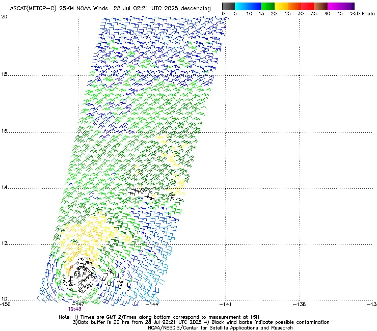
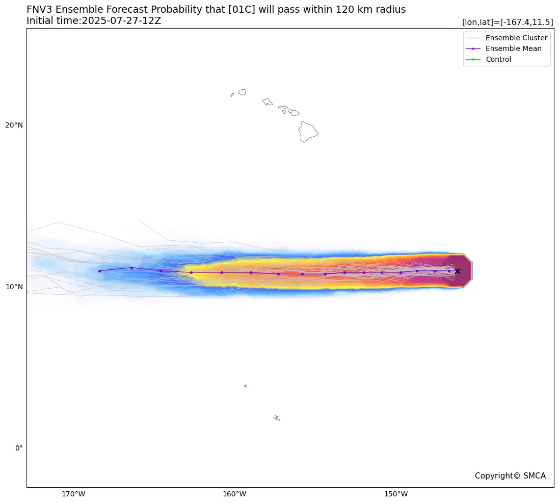
https://i.meee.com.tw/7LQ5isZ.png
【升格報+預測資料】
655
WTPA41 PHFO 280231
TCDCP1
Tropical Storm Iona Discussion Number 4
NWS Central Pacific Hurricane Center Honolulu HI CP012025
Issued by NWS National Hurricane Center Miami FL
500 PM HST Sun Jul 27 2025
A strong burst of deep convection with very cold cloud tops below
-80C developed over the low-level center of the tropical cyclone
well southeast of the Hawaiian Islands earlier this morning into the
early afternoon. This activity has recently subsided, but the
satellite presentation has improved since the previous advisory,
with well-defined banding structures now evident. The latest
subjective Dvorak intensity estimates from PHFO, SAB, and JTWC all
came in at 2.5/35 knots, while the objective intensity estimates
ranged from 35 to 42 knots. Taking a blend of these data, the
initial intensity for this advisory has been raised to, perhaps a
conservative 35 knots, making Iona the first named storm of the
season in the central Pacific.
Tropical Storm Iona is moving westward at 270/9 knots. This general
westward motion is expected to continue during the next couple of
days as the system moves along the southern periphery of a
subtropical ridge to the north. By Tuesday night or Wednesday, Iona
is expected to increase its forward speed due to a strengthening
low-to-mid-level ridge north of the system. The track forecast
closely follows a blend of the FSSE and HCCA consensus guidance and
is very close to the track from the previous advisory. Confidence
remains high that Iona will stay well to the south of the Hawaiian
Islands.
The environment appears conducive to further intensification over
the next day or so, as Iona remains over warm waters around 28C,
with adequate mid-level moisture and very light vertical wind shear.
As a result, the intensity forecast calls for steady strengthening,
with the cyclone expected to near hurricane strength by Monday night
or Tuesday. However, by Tuesday night, Iona will begin to move over
slightly cooler waters, begin to feel the influence of increasing
westerly vertical wind shear, and start to entrain drier mid-level
air. This is expected to result in steady weakening, with the
cyclone likely becoming a post-tropical remnant low by Day 5 and
potentially weakening into a trough by that time. The intensity
forecast has been raised from the previous advisory, following the
latest trends in the intensity guidance, and is best aligned with
the FSSE and HCCA consensus guidance.
FORECAST POSITIONS AND MAX WINDS
INIT 28/0300Z 10.9N 148.3W 35 KT 40 MPH
12H 28/1200Z 11.0N 149.7W 45 KT 50 MPH
24H 29/0000Z 11.0N 151.7W 55 KT 65 MPH
36H 29/1200Z 11.0N 153.8W 60 KT 70 MPH
48H 30/0000Z 11.1N 156.4W 60 KT 70 MPH
60H 30/1200Z 11.5N 159.4W 50 KT 60 MPH
72H 31/0000Z 12.1N 162.9W 45 KT 50 MPH
96H 01/0000Z 13.0N 170.4W 35 KT 40 MPH
120H 02/0000Z 14.4N 177.4W 30 KT 35 MPH...POST-TROP/REMNT LOW
$$
Forecaster Jelsema (CPHC)
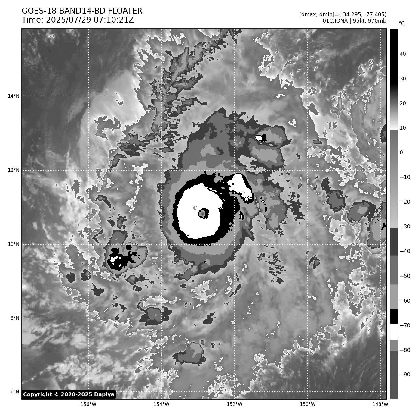
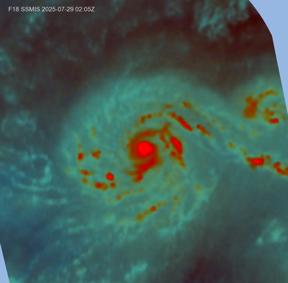
https://i.meee.com.tw/pGIfNFR.png
【衛星定位分析】
--
TXPN41 PHFO 272340
TCSNP1
CENTRAL PACIFIC TROPICAL CYCLONE SUMMARY - FIXES
NWS CENTRAL PACIFIC HURRICANE CENTER HONOLULU HI
2330 UTC SUN JUL 27 2025
A. TROPICAL DEPRESSION ONE-C CP012025
B. 27/2330Z
C. 11.0N
D. 147.8W
E. GOES-18
F. T2.5/2.5/D1.0/24 HRS
G. VIS/IR/EIR
H. REMARKS...0.45 WRAP ON LOG10 SPIRAL YIELDS A DT OF 2.5. PT AND
MET AGREE AT 2.5. FT BASED ON DT.
I. ADDL POSITIONS
$$
KINO
--
TPPZ01 PGTW 272358
A. TROPICAL DEPRESSION 01C (SE OF HILO)
B. 27/2300Z
C. 10.89N
D. 147.72W
E. SIX/GOES18
F. T2.5/2.5/D1.5/21HRS STT: D0.5/03HRS
G. IR/EIR/VIS/MSI
H. REMARKS: 44A/PBO LARGE CDO/ANMTN. IRREGULAR CDO OF 85NM IN
DIAMETER YIELDS A CF OF 2.0. ADDED 0.5 FOR BF TO YIELD A DT OF 2.5.
MET YIELDS 1.5. PT YIELDS 2.5. DBO DT.
I. ADDITIONAL POSITIONS: NONE
NEVAREZ
--
TXPN26 KNES 280025
TCSCNP
A. 01C (NONAME)
B. 28/0000Z
C. 11.0N
D. 147.7W
E. THREE/GOES-W
F. T2.5/2.5
G. IR/EIR/VIS
H. REMARKS...4/10 BANDING YIELDS A DT OF 2.5. THE MET IS 2.0. THE PT
IS 2.5. THE FT IS BASED ON THE DT.
I. ADDL POSITIONS
NIL
...GATLING
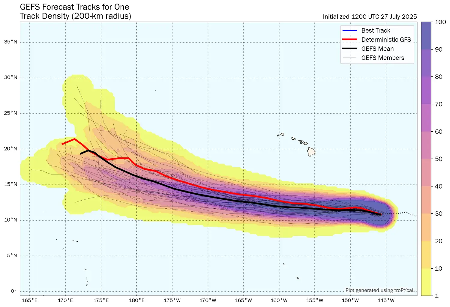
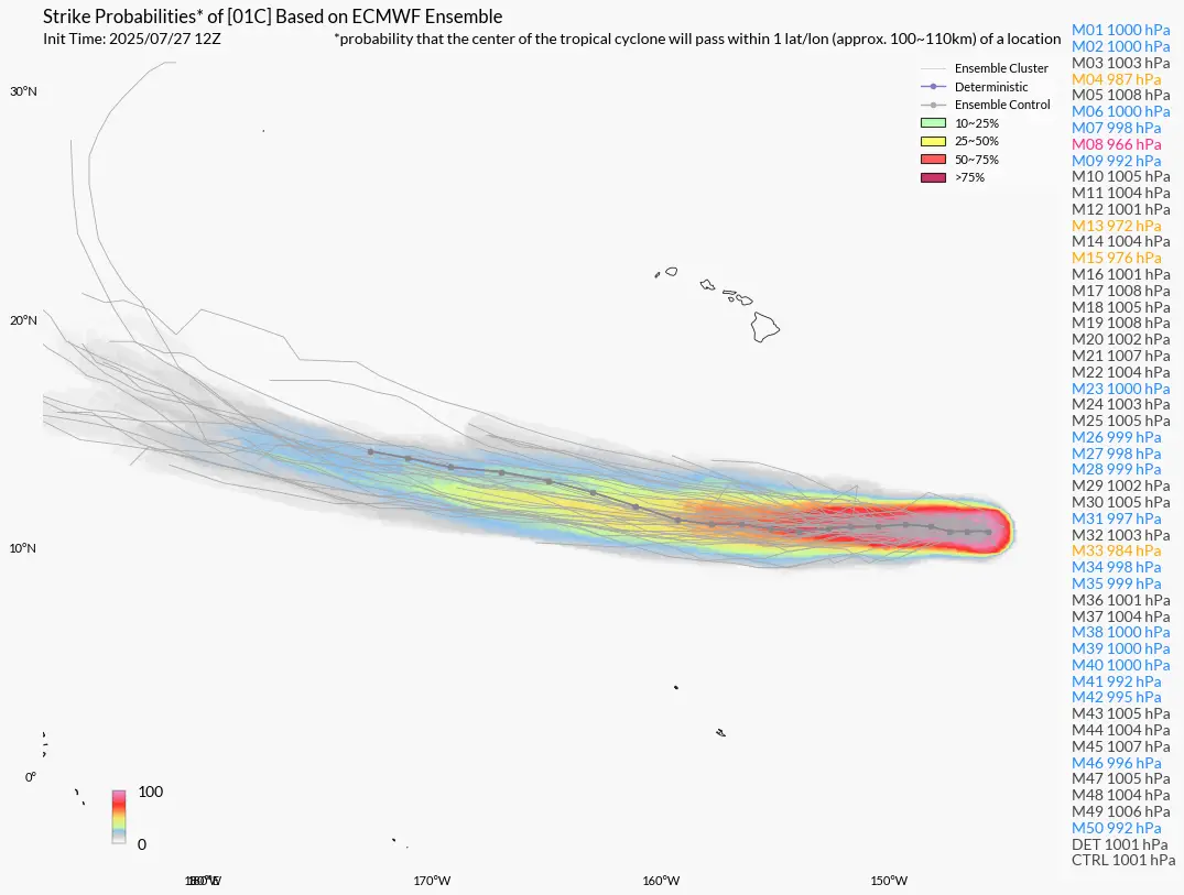
【系集路徑預報】
--
GFS
https://i.meee.com.tw/2OYMtNl.png
ECMWF
https://i.meee.com.tw/X5KXX5e.png
谷歌
https://i.meee.com.tw/fxUQ1lT.png
--
超遠…
天干,先質疑
01C旁邊還有02C 中太平洋熱鬧
開眼了欸
底層強悍

C4應該半夜達標
今年風王預備?
看能不能跨區
爆
Re: [颱風] 2418-山陀兒CWA今天下午3點直氣象說明會的雨量預測 JTWC第6報 Tropical Storm KRATHON As of 12:00 UTC Sep 28, 2024:![Re: [颱風] 2418-山陀兒](https://i.imgur.com/zqRAdJzb.jpeg "Re: [颱風] 2418-山陀兒")
爆
Re: [颱風] 2418-山陀兒JTWC 第5報 Tropical Storm KRATHON As of 06:00 UTC Sep 28, 2024: Location: 18.5衹 125.6蚩![Re: [颱風] 2418-山陀兒](https://i.imgur.com/2nb0GyLb.png "Re: [颱風] 2418-山陀兒")
爆
Re: [颱風] 2424 萬宜這波四颱當初最看壞的一個,理論上今天應該不在了。 結果![Re: [颱風] 2424 萬宜](https://i.imgur.com/jpkXCayb.gif "Re: [颱風] 2424 萬宜")
62
Re: [颱風] 2418-山陀兒JTWC第7報 Tropical Storm KRATHON As of 18:00 UTC Sep 28, 2024: Location: 18.7衹 124.9蚩 Maximum Winds: 50 kt![Re: [颱風] 2418-山陀兒](https://i.imgur.com/XOPrDNBb.png "Re: [颱風] 2418-山陀兒")
58
[討論] 18W 生成95W 升格 18W了 JTWC第1報 MSGID/GENADMIN/JOINT TYPHOON WRNCEN PEARL HARBOR HI// SUBJ/TROPICAL DEPRESSION 18W (EIGHTEEN) WARNING NR 001// REF/A/MSG/JOINT TYPHOON WRNCEN PEARL HARBOR HI/052251ZSEP2021![[討論] 18W 生成](https://i.imgur.com/8wl9K0Kb.gif "[討論] 18W 生成")
48
[颱風] 2426 帕布WTPQ50 RJTD 230600 RSMC TROPICAL CYCLONE ADVISORY NAME TS 2426 PABUK (2426) UPGRADED FROM TD ANALYSIS PSTN 230600UTC 11.1N 112.5E FAIR![[颱風] 2426 帕布](https://i.imgur.com/mRnq3cRb.jpg "[颱風] 2426 帕布")
44
[情報] 16W生成遠洋來的訪客16W JTWC第一報 GFS系集![[情報] 16W生成](https://i.imgur.com/u1XjVXlb.gif "[情報] 16W生成")
36
[颱風] 2301 珊瑚WTPN31 PGTW 210300 MSGID/GENADMIN/JOINT TYPHOON WRNCEN PEARL HARBOR HI// SUBJ/TROPICAL STORM 01W (SANVU) WARNING NR 007// RMKS/ 1. TROPICAL STORM 01W (SANVU) WARNING NR 007![[颱風] 2301 珊瑚](https://i.imgur.com/TkvAowkb.jpg "[颱風] 2301 珊瑚")
25
[情報] 01W 形成TROPICAL DEPRESSION 01W (ONE) WARNING NR 001 01 ACTIVE TROPICAL CYCLONE IN NORTHWEST PACIFIC OCEAN MAX SUSTAINED WINDS BASED ON ONE-MINUTE AVERAGE WIND RADII VALID OVER OPEN WATER ONLY --- WARNING POSITION: 111800Z --- NEAR 9.6N 128.8E![[情報] 01W 形成](https://i.imgur.com/WxEat8Nb.gif "[情報] 01W 形成")
4
Re: [颱風] 202019 天鵝 (JTWC 10/31 00Z PR)JTWC 10/31 00Z PROGNOSTIC REASONING WDPN31 PGTW 310300 MSGID/GENADMIN/JOINT TYPHOON WRNCEN PEARL HARBOR HI// SUBJ/PROGNOSTIC REASONING FOR SUPER TYPHOON 22W (GONI) WARNING NR 013//![Re: [颱風] 202019 天鵝 (JTWC 10/31 00Z PR)](https://upload.cc/i1/2020/10/31/J8NqFY.png "Re: [颱風] 202019 天鵝 (JTWC 10/31 00Z PR)")
![[討論] 93W TD[W]](https://i.duk.tw/sa3bLi.png "[討論] 93W TD[W]")